


Hurricane Erin is already wreaking havoc along the East Coast — and it hasn’t even made landfall.
As the massive storm crawled closer to the U.S. on Tuesday, emergency officials were already scrambling, according to the Associated Press.
Dozens of swimmers have been rescued, evacuations are underway, and state leaders are warning beachgoers to stay out of the water — even before the biggest storm surges hit.
Rip current alerts now stretch from Florida to New England, and New York City has closed its beaches to swimming on Wednesday and Thursday. Several beaches across Long Island and New Jersey are also going off-limits.
“Enjoy the shore, enjoy this beautiful weather but stay out of the water,” New Jersey Gov. Phil Murphy urged Tuesday.
While the National Hurricane Center remains confident that Erin’s center will stay offshore, its outer bands are packing a punch — delivering tropical-force winds, dangerous rip currents, and massive waves to the entire eastern seaboard.
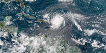
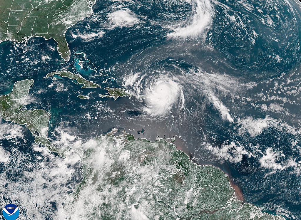
The hurricane, which weakened slightly to a Category 2 on Tuesday, still has maximum sustained winds of 105 mph (170 kph) and was located 655 miles (1,050 kilometers) south-southeast of Cape Hatteras, North Carolina.
But don’t let the downgrade fool you — Erin is massive, with tropical storm winds extending 200 miles from its center and expected to expand even further.
Off the coast of Massachusetts, Nantucket Island could see waves over 10 feet (3 meters) later this week. But the Outer Banks of North Carolina remains the bullseye for the storm’s most dangerous impacts.
Mandatory evacuations were issued for Hatteras and Ocracoke Islands, where more than 1,800 people have already left Ocracoke by ferry since Monday. Residents were told to tie down trash cans, pack up, and get out before storm surge swallows roads.
Local store owner Tommy Hutcherson told the AP that while “some people are evacuating,” others are hunkering down, riding out the storm like they’ve done before.
On Hatteras Island, crews raced to shore up dunes while some residents dismantled parts of a pier to reduce the storm surge’s damage. North Carolina Gov. Josh Stein declared a state of emergency, warning coastal residents to stay alert.
Meanwhile, rough surf has already turned dangerous. On Monday alone, at least 60 swimmers were rescued from rip currents at Wrightsville Beach, near Wilmington, North Carolina.
The biggest swells are expected Wednesday through Thursday, and that’s just the beginning.
Erin isn’t just big — it’s also deceptively dangerous. “It’s just one of those things where you know this is always a possibility,” said Holly Andrzejewski, who recently bought a B&B on Hatteras Island. She and her husband spent days prepping: “You just make the best out of it. Otherwise you wouldn’t live at the beach.”
In the Turks and Caicos, the storm lashed the islands Tuesday, with government services suspended and residents ordered to stay home, as Erin continues its trek past the Bahamas toward Bermuda and the U.S.
The thin, low-lying Outer Banks, increasingly vulnerable to rising seas and storm surges, could face 15-foot waves (4.6 meters) and washed-out roads, possibly cutting off access for days.
Two years ago, Hurricane Lee stunned forecasters with how fast it intensified. Now, climate scientists warn that Atlantic hurricanes are doing just that — turning bigger and more dangerous, more quickly, fueled by warmer oceans.
With Erin growing larger by the hour, coastal residents from the Carolinas to Cape Cod are bracing for what could be the storm of the season — and it’s still days from moving out.


