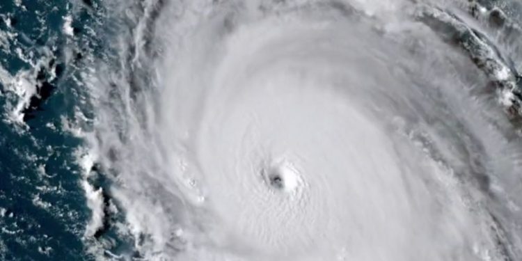
Hurricane Lee roared into what forecasters were calling a “monster” on Friday.
AccuWeather called the storm “a monster Category 5 hurricane” that could take aim at New England by the time it reaches North America.
On Thursday, the storm was a Category 1 hurricane with maximum sustained winds of 80 miles per hour. On Friday morning, its winds were hitting 165 miles per hour.
AccuWeather noted that hurricanes can experience what is called rapid intensification when winds increase by 35 mph or more within a 24-hour period. Lee’s vast growth in power, it said, was “extremely rare.”
Hurricane #Lee has explosively intensified into a Category 5 storm and is expected to peak as a monster 180 mph Cat 5.
One of the fastest intensifying Atlantic hurricanes ever observed. pic.twitter.com/38efxc07Bj
— Colin McCarthy (@US_Stormwatch) September 8, 2023
“Hurricane #Lee has explosively intensified into a Category 5 storm and is expected to peak as a monster 180 mph Cat 5. One of the fastest intensifying Atlantic hurricanes ever observed,” storm chaser Colin McCarthy wrote on X.
The storm is still several hundred miles out in the Atlantic. Current projections are that it will move north of the Caribbean through the weekend, and then move north.
After that, impact predictions are largely speculation, although AccuWeather noted that the “threat of direct impacts in New England is increasing, and much of the East Coast will experience heavy seas and dangerous surf.”
“Changes in Lee’s eye structure will result in some fluctuation in the strength of the hurricane through this weekend,” AccuWeather Chief On-Air Meteorologist Bernie Rayno said. “However, it is not likely to dip below major hurricane intensity [Category 3 or greater] and could spend much of the weekend at Category 4 intensity or greater.”
?#BREAKING: In just over 24 hours, Hurricane Lee has rapidly intensified from a tropical storm to an extremely dangerous and powerful Category 5 hurricane, with sustained winds of 160 mph, as it barrels through the Atlantic. pic.twitter.com/vC994c0SRB
— R A W S A L E R T S (@rawsalerts) September 8, 2023
Although Lee is not expected to hit Florida directly, the state will still be impacted.
“Starting as early as Sunday, seas and surf will build to dangerous levels along the central and northern coast of Florida and expand northward through the mid-Atlantic and New England coasts next week,” AccuWeather Senior Meteorologist Joe Lundberg said.
The path of the jet stream will direct Lee. Under some scenarios, it is projected to hit New England.
“The area in the United States that really needs to pay attention includes locations from the upper part of the mid-Atlantic coast to New England,” Rayno said, noting the east coast of Canada could also face impacts.
Updated model output from NOAA GFS shows the evolution of powerful Hurricane Lee interacting with a cold front as it moves along U.S. East coast next week.
Lee will be weaker but larger and becoming post-tropical as it races north w/potential direct impacts from New England to… pic.twitter.com/MlMF1LrOzp
— Ryan Maue (@RyanMaue) September 8, 2023
“It looks like Lee is rapidly strengthening right now, and we expect it to continue to quickly strengthen,” AccuWeather Senior Meteorologist John Feerick said, according to the Boston Herald.
“It’s difficult to say this far out, but there’s potential for this to impact the East Coast from the Carolinas up into New England as we head into late next week.
Even if the storm churns off the coast, dangerous surf and rip currents could hit New England.
“Even if Lee were to curve out to sea and miss southern New England, a potential impact could be rough surf and rip currents,” said Torry Gaucher, meteorologist at the National Weather Service’s Boston office. “It’s definitely something you’ll want to keep checking in on over the next several days.”
Although remnants of hurricanes and tropical storms often strike the northern part of America’s Atlantic coast, direct hits are relatively rare.
Lee’s approach toward the Northeast comes 11 years after superstorm Sandy clobbered New York City and New England in late October of 2012, noted the National Oceanic and Atmospheric Administration.
By the time the storm was done, it had caused $68 billion in damage, closed the New York Stock Exchange for two straight days for the first time since 1888 and left 186 people dead.
In late September 1985, Hurricane Gloria slammed into Long Island causing widespread flooding and about $900 million in damage, the National Weather Servicenoted.
This article appeared originally on The Western Journal.


 Continue with Google