

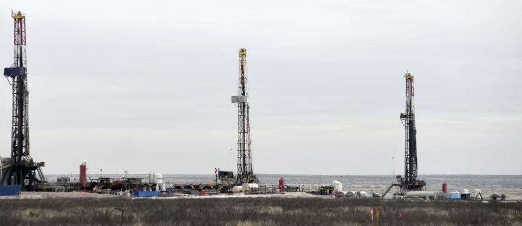
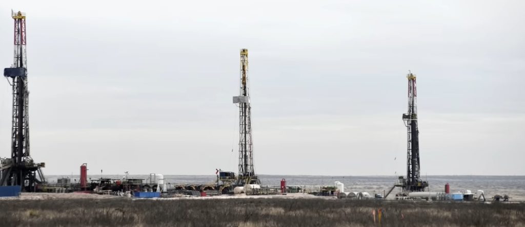
The Permian Basin is a large sedimentary basin in the southwestern part of the United States. It is the highest-producing oil field in the US, producing an average of 4.2 million barrels of crude oil per day in 2019. This sedimentary basin is located in western Texas and far-southeastern New Mexico.
It is named after the Permian geologic period, the final period of the Paleozoic era, as it contains some of the world's thickest deposits of rocks from the period.
The Permian Basin comprises several component basins, including the Midland Basin, which is the largest; Delaware Basin, the second largest; and Marfa Basin, the smallest. The Permian Basin covers more than 86,000 square miles (220,000 km2), and extends about 250 miles (400 km) wide and 300 miles (480 km) long.
The Texas cities of Midland, Odessa, and San Angelo serve as headquarters for some of the oil production activities in the basin.
The Permian Basin is also a major source of potassium salts (potash). Potash mines are located in Lea and Eddy counties, New Mexico, and are operated by the room and pillar method. Halite (rock salt) is produced as a byproduct of potash mining.
Contents
Components
Delaware Basin
The Delaware Basin is the larger of the two major lobes of the Permian Basin within the foreland of the Ouachita–Marathon thrust belt separated by the Central Basin Platform. The basin contains sediment dating to Pennsylvanian, Wolfcampian (Neal Ranch and Lenox Hills Formations), Leonardian (Avalon Shale), and early Guadalupian times.
The eastward-dipping Delaware basin is subdivided into several formations (figure 2) and contains about 25,000 feet (7,600 m) of laminated siltstone and sandstone. Aside from clastic sediment, the Delaware basin also contains carbonate deposits of the Delaware Mountain Group, originating from the Guadalupian times when the Hovey Channel allowed access from the sea into the basin.
Midland Basin
The westward-dipping Midland Basin is subdivided into several formations (figure 4) and is composed of laminated siltstone and sandstone. The Midland Basin was filled by a large subaqueous delta that deposited clastic sediment into the basin. Aside from clastic sediment, the Midland Basin also contains carbonate deposits originating from the Guadalupian times when the Hovey Channel allowed access from the sea into the basin.
Central Basin Platform
The Central Basin Platform (CBP) is a tectonically uplifted basement block capped by a carbonate platform. The CBP separates the Delaware and Midland Basins and is subdivided into several formations, from oldest to youngest Neal Ranch, Lennox Hills, Abo, Yeso, Glorieta, San Andres, Grayburg, Queen, Seven Rivers, Yates, and Tansill Formations (Figure 5). The sequence mainly comprises carbonate reef deposits and shallow marine clastic sediments.
Eastern and Northwest Shelves
The Eastern and Northwestern Shelves are composed of shelf edge reefs and shelf carbonates flanking the Delaware and Midland Basins that grade up-dip into siltstones and evaporites. The Eastern and Northwestern Shelves are subdivided into the San Andres, Grayburg, Queen, Seven Rivers, Yates, and Tansill Formations.
San Simon Channel
The San Simon Channel is a narrow syncline that separated the Central Basin Platform from the Northwestern Shelf during Leonardian and Guadalupian times.
Sheffield Channel
The Sheffield Channel separates the southern margin of the Midland Basin from the southern shelf and the Ouachita–Marathon thrust-belt during Leonardian and Guadalupian times.
Hovey Channel
The Hovey Channel is a topographical low located on the southern edge of the Delaware Basin, allowing access to the Panthalassa sea during Guadalupian times. The Hovey Channel was originally an anticline which formed during Precambrian faulting, and was the main source of sea water for the Delaware Basin. The closing of the Hovey Channel towards the end of the Permian Period eventually caused the death of the Permian Reef, as without water being brought in through the Channel, salinity levels rose drastically in the Delaware Basin and the reef could not survive.
Horseshoe Atoll
The Horseshoe Atoll is a westward-tilting arcuate chain of reef mounds 175 miles (282 km) long located in the Midland Basin, consisting of 1,804 feet (550 m) of limestone accumulated in the Pennsylvanian and 1,099 feet (335 m) in the Permian, with 15 significant petroleum reservoirs from 6,099 feet (1,859 m) to 9,902 feet (3,018 m) in depth.
The reef complex consists of Upper Pennsylvanian Strawn, Canyon and Cisco limestones, overlain by Lower Permian Wolfcamp sandstones and shales of terrigenous origin prograding northeast to southwest. The first production well, Seabird Oil Company of Delaware No. 1-B J. C. Caldwell, was completed in 1948.
Depositional history
The Permian Basin is the thickest deposit of Permian-aged rocks on Earth; they were rapidly deposited during the collision of North America and Gondwana (South America and Africa) between the late Mississippian through the Permian. The Permian Basin also includes formations that date back to the Ordovician Period, 445 million years ago (mya).
Proterozoic
Before the breakup of the Precambrian supercontinent and the formation of the modern Permian Basin geometry, shallow marine sedimentation onto the ancestral Tobosa Basin characterized the passive margin, shallow marine environment. The Tobosa Basin also contains basement rock that dates back to 1,330 million years ago (mya), and that is still visible in the present-day Guadalupe Mountains. The basement rock contains biotite-quartz granite, discovered at a depth of 12,621 feet (3,847 m).
In the nearby Apache and Glass Mountains, the basement rock is made of metamorphosed sandstone and Precambrian-aged granite. The entire area is also underlain by layered mafic rocks, which are thought to be a part of Pecos Mafic Igneous Suite, and extends 220 miles (360 km) into the southern US. It has been dated to 1,163 mya.
Early to mid-Paleozoic (Late Cambrian to Mississippian)
Each period from the Paleozoic Era has contributed a specific lithology to the Tobosa Basin, accumulating into almost 6,600 feet (2,000 m) of sediment at the start of the Pennsylvanian Period (323.2–298.9 mya). The Montoya Group is the youngest rock formation in the Tobosa Basin and was formed in the Ordovician Period (485.4–443.8 mya), and sit directly on the igneous and metamorphic basement rocks.
The rocks from the Montoya Group are described as light to medium grey, fine to medium grained crystalline calcareous dolomite. These rocks were sometimes inter-bedded with shale, dark-grey limestone, and, less commonly, chert. the Montoya Group sequence is made up of carbonate limestone and dolomite which is described as dense, impermeable, and non-porous, and is more commonly found in the Glass Mountains outcrop, with thickness varying from 151 to 509 feet (46 to 155 m).
During the Silurian Period, the Tobosa Basin experienced dramatic changes in sea level which led to the formation of multiple rock groups. The first of these groups, called the Fusselman Formation, is mostly made up of light grey, medium to coarse grained dolomite. The thickness of this formation varies from 49 to 164 feet (15 to 50 m), and parts of the Fusselman Formation were also subject to karstification, which indicates a drop in sea level.
The second rock group that formed during the Silurian Period is called the Wristen Formation, which is mud, shale, and dolomite rich rock that reaches a thickness of 1,480 feet (450 m) in some places. Karstification of the Fusselman Formation shows that a drop in sea level occurred, but sea levels rose again during a transgressive event, which lead to the creation of the Wristen Formation. Sea levels then dropped again, which led to major exposure, erosion, and karstification of these formations.
The Thirtyone Formation was developed during the Devonian Period. This formation is characterized by its limestone, chert, and shale beds, some of which had a peak thickness of 980 feet (300 m). this formation had many different types of limestone, including light-colored siliceous, chert-dominated, crinoid-rich, and sandy limestone. The Thirtyone Formation is very similar to the formation of the Mississippian Period, which is likely because there was little to no change in the environment during this time.
Late Paleozoic (Pennsylvanian to Permian)
The Pennsylvanian Period marked the beginning of geological processes that would shape the Permian Basin into what we see today. Rifting events during the Cambrian Period (early Paleozoic) left fault zones in the region. These fault zones acted as planes of weakness for faulting that was later initiated by the Ouachita Orogeny.
These fault zones caused the Tobosa Basin to be transformed, due to tectonic activity, into the Permian Reef Complex, which comprises three parts: the Central Basin Platform, which is encircled by faults, and the Midland and Delaware Basins on either side. Mississippian sediments are absent either due to erosion or nondeposition. Marine shales were deposited in the center of the Delaware, Midland and Val Verde basins, while the basins' periphery saw the deposition of shallow marine, carbonate shelf and limestone sediments.
The Early Pennsylvanian Morrow Formation underlies the Atoka Formation. The Morrow is an important reservoir consisting of clastic sediments, sandstones and shales, deposited in a deltaic environment.
The Pennsylvanian Period also led to the development of other geologic formations, although none had the importance of the Morrow Formation. The Atoka Formation lies conformably on top of the Morrow Formation, and is characterized by its fossil-rich limestone inter-bedded with shale, reaching a max thickness of 660 feet (200 m). During the formation of the Atoka, uplift was still occurring in the region, leading to increased sedimentation as the surrounding highlands were eroded. The increased sedimentation led to the formation of medium- to coarse-grained sandstone. In the Atoka Formation, the first reef structures that formed in the Delaware Basin are visible.
The Strawn Formation formed after the Atoka, also during the Pennsylvanian Period, and reached a max thickness of 660 feet (200 m). In this formation, there was a significant increase in reef mounds. The Strawn Formation is primarily made up of massive limestone, along with "fine to medium-grained sandstone, dark to light-grey shale, and occasional reddish-brown, greenish-grey, bituminous shale". A great number of different fossil types were preserved in this formation, including brachiopods, foraminifera, bryozoans, corals, and crinoids.
Generalized facies tracts of the Permian Basin
The Permian basin is divided into generalized facies belts differentiated by the depositional environment in which they formed, influenced by sea level, climate, salinity, and access to the sea.
Lowstand systems tract
Lowering sea level exposes the peritidal and potentially, the shelf margin regions, allowing linear channel sandstones to cut into the shelf, extending beyond the shelf margin atop the slope carbonates, fanning outward toward the basin. The tidal flats during a lowstand contain aeolian sandstones and siltstones atop supratidal lithofacies of the transgressive systems tract. The basin fill during a lowstand is composed of thin carbonate beds intermingled with sandstone and siltstone at the shelf and sandstone beds within the basin.
Transgressive systems tract
These facies results from the abrupt deepening of the basin and the reestablishment of carbonate production. Carbonates such as bioturbated wackstone and oxygen-poor lime mud accumulate atop the underlying lowstand systems tract sandstones in the basin and on the slope. The tidal flats are characterized by supratidal faces of hot and arid climate such as dolomudstones and dolopackstones. The basin is characterized by thick carbonate beds on or close to the shelf with the shelf margin becoming progressively steeper and the basin sandstones becoming thinner.
Highstand systems tract
Highstand systems tract facies results from the slowing down in the rise of sea level. It is characterized by carbonate production on the shelf margin and dominant carbonate deposition throughout the basin. The lithofacies is of thick beds of carbonates on the shelf and shelf margin and thin sandstone beds on the slope. The basin becomes restricted by the formation of red beds on the shelf, creating evaporites in the basin.
Tectonic history
During the Cambrian–Mississippian, the ancestral Permian Basin was the broad marine passive margin Tobosa Basin containing deposits of carbonates and clastics. In the early Pennsylvanian–early Permian the collision of North American and Gondwana Land (South America and Africa) caused the Hercynian orogeny. The Hercynian orogeny resulted in the Tobosa basin being differentiated into two deep basins (the Delaware and the Midland Basins) surrounded by shallow shelves. During the Permian, the basin became structurally stable and filled with clastics in the basin and carbonates on the shelves.
Lower Paleozoic passive margin phase (late Precambrian–Mississippian, 850–310 mya)
This passive margin succession is present throughout the southwestern US and is up to 0.93 miles (1.5 km) thick. The ancestral Permian basin is characterized by weak crustal extension and low subsidence in which the Tobosa basin developed. The Tobosa basin contained shelf carbonates and shales.
Collision phase (late Mississippian–Pennsylvanian, 310–265 mya)
The two lobed geometry of the Permian basin separated by a platform was the result of the Hercynian collisional orogeny during the collision of North America and Gondwana Land (South America and Africa). This collision uplifted the Ouachita-Marathon fold belt and deformed the Tobosa Basin. The Delaware Basin resulted from tilting along areas of Proterozoic weakness in Tobosa basin. Southwestern compression reactivated steeply dipping thrust faults and uplifted the Central Basin ridge. Folding of the basement terrane split the basin into the Delaware basin to the west and the Midland Basin to the east.
Permian Basin phase (Permian, 265–230 mya)
Rapid sedimentation of clastics, carbonate platforms and shelves, and evaporites proceeded synorogenically. Bursts of orogenic activity are divided by three angular unconformities in basin strata. Evaporite deposits in the small remnant basin mark the final stage of sedimentation as the basin became restricted from the sea during sea level fall.
Hydrocarbon production and reserves
The Permian Basin is the largest petroleum-producing basin in the United States and has produced a cumulative 28.9 billion barrels of oil and 75 trillion cubic feet of gas. In early 2020, over 4 million barrels of oil a day were being pumped from the basin. Eighty percent of estimated reserves are located at less than 10,000 feet (3,000 m) depth. Ten percent of the oil recovered from the Permian Basin has come from Pennsylvanian carbonates.
The largest reservoirs are within the Central Basin Platform, the Northwestern and Eastern shelves, and within Delaware Basin sandstones. The Primary lithologies of the major hydrocarbon reservoirs are limestone, dolomite, and sandstone due to their high porosities. However, advances in hydrocarbon recovery such as horizontal drilling and hydraulic fracturing have expanded production into unconventional, tight oil shales such as those found in the Wolfcamp Shale.
History of resources
In 1917, J.A. Udden, a University of Texas geology professor, speculated that the Marathon Fold, associated with the Marathon Mountains, may extend northward. This fold theory was further elaborated on in 1918 by geologists R.A. Liddle and J.W. Beede. The potential structure was thought to be a potential trap for oil. Based on this Marathon Fold theory, and known oil seeps, test drilling commenced in the eastern Permian Basin.
Oil reserves in the Permian Basin were first documented by W.H. Abrams in Mitchell County, West Texas in 1920. The first commercial well was opened in 1921, in the newly discovered Westbrook Oil Field in Mitchell County, at a depth of 2,498 feet (761 m). Initially, the Permian Basin was thought to have a bowl-like shape, with geological survey crews unable to study the inside of the basin due to a lack of outcrops.
The next few years contained discoveries of multiple oil fields, such as the Big Lake oil field (1923), the World oil field (1925), the McCamey oil field (1925), the Hendrick oil field (1926), and the Yates Oil Field (1926). All of these discoveries were made by random drilling or surfacing mapping. Geophysical tests were vital in mapping the region, since tools such as seismographs and magnetometers were used to find anomalies in the area.
By 1924, companies establishing regional geological offices in the basin included the California Company (Standard Oil of California), Gulf Oil, Humble (Standard Oil of New Jersey), Roxana (Shell Oil Company), Dixie Oil (Standard Oil of Indiana), Midwest Exploration (Standard Oil of Indiana), and The Texas Company.
Due to distances and lack of pipes in which to move oil, deep drilling tests were few in the 1920s, since the costs were high. As a result, all the oil wells up to 1928 were less than 5,000 feet (1,500 m) or 6,000 feet (1,800 m) deep. In 1928, the No. I-B University discovery well found oil at 8,520 feet within the Ordovician formations of Big Lake. Exploration and development increased in the 1930s with the discovery of the Harper oil field (1933), the Goldsmith oil field (1934), the Foster oil field (1935), the Keystone oil field (1935), the Means oil field (1934), the Wasson oil field (1936–1937), and the Slaughter Field (1936).
During World War II the need for oil in the US became urgent, justifying the high costs of deep oil drilling. This breakthrough led to major oil reservoirs being found in every geological formation from the Cambrian Period to the Permian Period. Significant discoveries included the Embrar oil field (1942), the TXL oil field (1944), the Dollarhide oil field (1945), and the Block 31 oil field (1945).
Current production
As of 2018, the Permian Basin has produced more than 33 billion barrels of oil, along with 118 trillion cubic feet of natural gas. This production accounts for 20% of US crude oil production and 7% of US dry natural gas production. While the production was thought to have peaked in the early 1970s, new technologies for oil extraction, such as hydraulic fracturing and horizontal drilling, have increased production dramatically. Estimates from the Energy Information Administration have predicted that proven reserves in the Permian Basin still hold 5 billion barrels of oil and approximately 19 trillion cubic feet of natural gas.
Environmental concerns
By October 2019, the fossil-fuel executives said that until recently they had been making progress in cutting back on flaring, which is to burn natural gas. Drilling companies focus on drilling and pumping oil, which is highly lucrative, but the less-valuable gas which is pumped along with the oil is considered to be a "byproduct". During the current boom in the Permian oil fields, drilling for oil has "far outpaced pipeline construction" so the use of flaring has increased along with venting "natural gas and other potent greenhouse gases directly into the atmosphere", causing considerably larger greenhouse effect than flaring. Both practices are legal under states' legislation.
Most of the methane emitted comes from a small number of sources. Satellite data show that 3.7% of gas produced from the Permian Basin is lost in leaks, equivalent to the consumption of 7 million Texas homes. The price of natural gas was so cheap that smaller companies that have the pipeline capacity are choosing to flare rather than pay pipeline costs.
Counties and municipalities of the Permian Basin
Due to its economic significance, the Permian Basin has also given its name to the geographic region in which it lies. The counties of this region include:
Andrews County pop. 18,705
Borden County pop. 648
Brewster County pop. 9,267
Chaves County pop. 64,615
Cochran County pop. 2,836
Coke County pop. 3,370
Concho County pop. 4,276
Cottle County pop. 1,389
Crane County pop. 4,794
Crockett County pop. 3,499
Crosby County pop. 5,737
Culberson County pop. 2,204
Dawson County pop. 12,728
Dickens County pop. 2,249
Ector County pop. 166,223
Eddy County pop. 58,460
Edwards County pop. 1,928
Fisher County pop. 3,974
Floyd County pop. 5,837
Gaines County pop. 20,901
Garza County pop. 6,578